Enhancing Community Engagement in Flood Mitigation Using Integrated Hydrodynamic Modeling and Multi-Scale Socio-Economic Risk Assessment
This project works with community stakeholders and groups in flood-prone communities to codevelop technological tools that will promote a broader and more comprehensive understanding of flood risks stimulating consensus and support for flood mitigation strategies that can reduce the devastating and costly impacts of flooding. Working closely with community stakeholders, the project will provide diverse groups access to easily comprehensible information and customized tools to engage in decision making and discover common ground facilitating conflict resolution.
The project team will support groups in identifying their current knowledge gaps and tool preferences, facilitating the development of appropriate technology for knowledge exchange and decision making. Additionally, the co-development of this technology will enhance social capital development at the individual and community scale. Through project generated educational and partnership opportunities, community-based groups and organizations will become more connected and smarter in dealing with flood risks. By advancing the state of the science through innovations in information and communication technologies to address flood risk and mitigation, the project will support the National Science Foundation's mission to promote the progress of science and advance the national health, prosperity, and welfare when addressing flood risks and supporting economically viable and sustainable solutions for flood mitigation.
The objective of this planning project is to identify how recent advances in hydroinformatics technologies including hydrodynamic modeling, geospatial visualization, and fusion of heterogeneous data for socioeconomic analysis, can empower diverse stakeholders in flood-prone communities to understand flood risks and engage in formulating and supporting flood mitigation strategies.
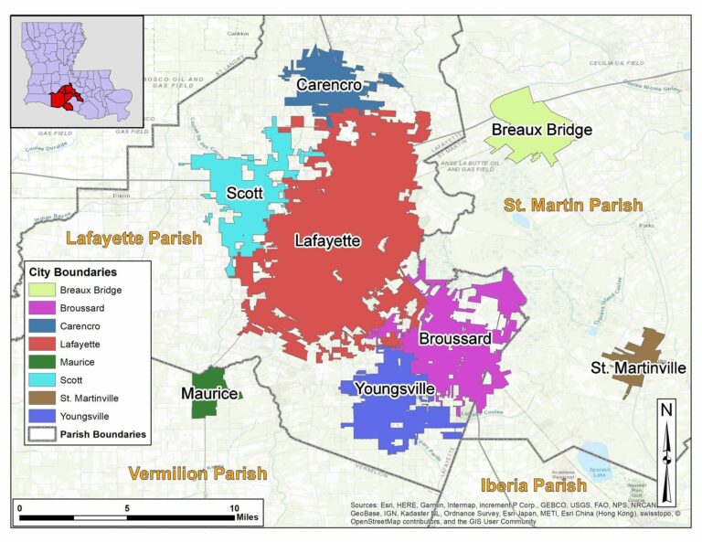
The community of interest is Lafayette Parish in Louisiana, USA, that exemplifies experiences of other US communities facing increasing flood risks caused by climate and land use changes. Recent research indicates that disparate levels of risk perception impact a community's ability to function cohesively. Individual risk is often understood through the lens of whether a particular location was flooded in a past flood, failing to capture the whole interconnected dimensions at the community level. Potential benefits of mitigation projects are often presented as deterministic without accounting for climate variability or projected land use changes. In addition to individual risk, economic and social conditions can amplify risks to specific populations and groups with communities.
The goals of this project are: (1) to test research hypotheses on possible solutions for reaching community consensus related to flooding risks and developing a shared vision for addressing these risks at individual and community scales; and (2) to refine a conceptual framework for using hydroinformatics technologies to overcome these challenges. In this project, we will conduct interviews and interactive workshops engaging diverse stakeholders to: a) assess information gaps about flood risk, b) identify web-based applications integrating hydrodynamic modeling, geospatial visualization, and socioeconomic analysis to enhance engagement and collaboration across multiple sectors, and c) develop technology-driven engagement tools informed by stakeholder needs.
For more information about the project, please visit the project website at https://ourfloodrisk.org/
This award reflects NSF's statutory mission and has been deemed worthy of support through evaluation using the Foundation's intellectual merit and broader impacts review criteria.
-
Performance PeriodOctober 2021 - September 2022
-
University of Louisiana at Lafayette
-
Award Number2125472
-
 Lead PIEmad Habib
 -
Co-PIElizabeth Skilton
-
Co-PIStephen Barnes
Project Material
- Anchoring tools to communities: insights into perceptions of flood informational tools from a flood-prone community in Louisiana, USA
- We don't want your water: Broadening community understandings of and engagement in flood risk and mitigation
- 2022: Frontiers Journal Paper on Focus Groups Research
- 2022: Transportation impact tool
- 2022: Structural Damage Tool
- 2022: Enhancing Community Engagement in Flood Mitigation Using Integrated Hydrodynamic Modeling and Multi-Scale Socio-Economic Risk Assessment
- 2022: Workshop on Flood Risk Information Tools
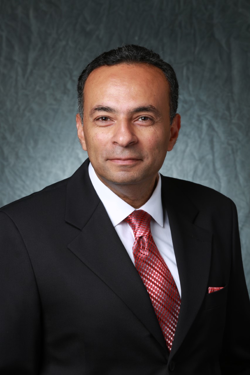
Dr. Emad Habib is an Endowed Chair in the College of Engineering and the Founder and Chair of the Watershed Flood Center at the University of Louisiana at Lafayette. He received his doctoral degree in Civil & Environmental Engineering in 2001 from the University of Iowa. His research expertise is in surface hydrology with focus on extreme precipitation; hydrologic modeling; flood prediction; and water resource management. He published more than 70 peer-reviewed journal articles and several book chapters. He received the 2016 University Distinguished Professor Award, and other awards including the Journal of Hydrologic Engineering Best Journal Award and the Watershed Excellence Award from the American Society of Civil Engineers. He is a Lead of the Technical Design and Quality Team for the Louisiana Watershed Initiative, and has participated in the 2012 and 2017 Louisiana Coastal Master Plan Study. Dr. Habib is a Professional Engineer registered in the states of Louisiana and Texas.